- hot-spots
- forest fire
- Canada
- Forest fires in Canada
Problems
Canada, due to its vast forests and diverse geography, experiences numerous forest fires every year.

Canada has about 9% of the world’s forests. Each year over the last 25 years, about 7,300 forest fires have occurred. The total area burned varies widely from year to year but averages about 2.5 million hectares annually.
Only 3% of all wildland fires that start each year in Canada grow to more than 200 hectares in area. However, these fires account for 97% of the total area burned across the country.
Fire suppression costs over the last decade in Canada have ranged from about $800 million to $1.5 billion a year.
Causes of fires
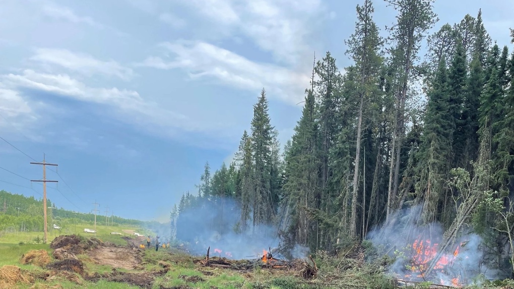
These fires occur in forests, shrublands and grasslands. Some are uncontrolled wildfires started by lightning or human carelessness and climate change.

A small number are prescribed fires set by authorized forest managers to mimic natural fire processes that renew and maintain healthy ecosystems.
Consequences of fires for forest management
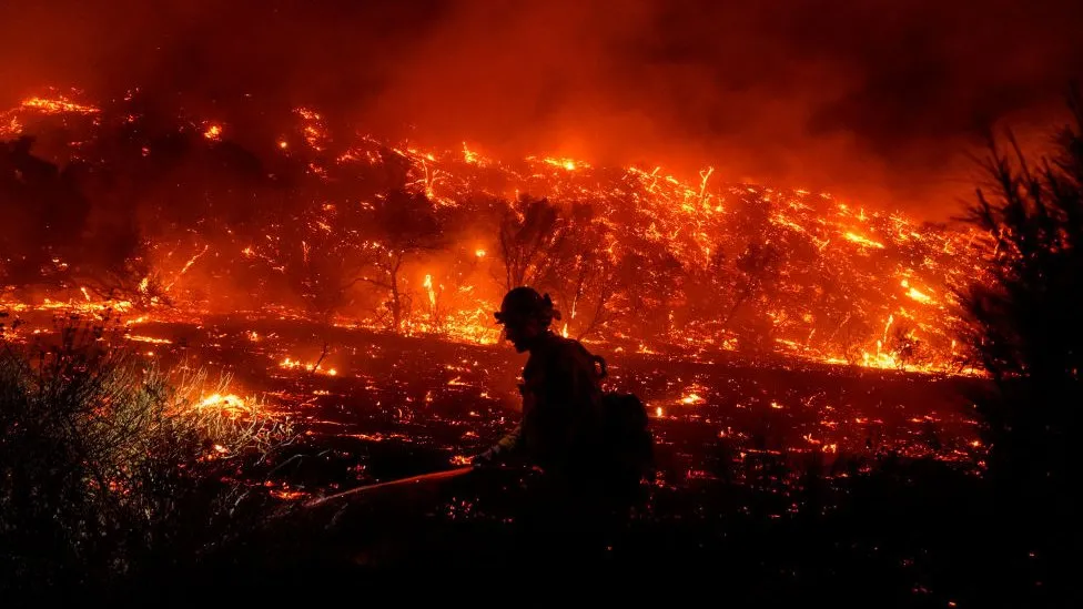
Wildland fires present a challenge for forest management because they have the potential to be at once harmful and beneficial. They can threaten communities and destroy vast amounts of timber resources, resulting in costly losses.

However, wildland fires are a natural part of the forest ecosystem and important in many parts of Canada for maintaining the health and diversity of the forest. In this way, prescribed fires offer a valuable resource management tool for enhancing ecological conditions and eliminating excessive fuel build-up.

Not all wildland fires should (or can) be controlled. Forest agencies work to harness the force of natural fire to take advantage of its ecological benefits while at the same time limiting its potential damage and costs.

This makes fire control strategies a vital component of forest management and emergency management in Canada.
Understanding the complex phenomenon of wildland fire
Understanding the complex phenomenon of wildland fire begins with understanding the basic physical aspects of fire and the ecological role of fire in forests and other wildland areas. Increasingly accurate assessments of the fire situation across Canada are now helping land managers use forest science to reduce fire risk and optimize the benefits.

Fire research by the CFS and its partners

The Canadian Forest Service (CFS) has been involved in fire research for decades. The CFS works with partners across the country to increase the knowledge base about wildland fires, and to improve the ability of authorities to predict and manage risks and benefits.
Gallery
15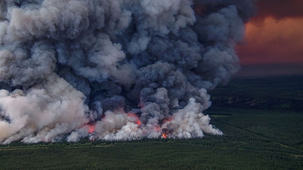
/cloudfront-us-east-2.images.arcpublishing.com/reuters/AR4H76I3QRISDGJIN3AQMOD4PM.jpg)
/cloudfront-us-east-2.images.arcpublishing.com/reuters/G6X63CVSTVLPLBQZ3EYJVWGDCA.jpg)


/cloudfront-us-east-2.images.arcpublishing.com/reuters/Z3KX7L67DJKB5KHIZSGVH3AQMY.jpg)


Timelines
2024
March
Canada’s emergency preparedness minister is warning that this year’s wildfire season will be worse than the record-breaking season of 2023.

So-called “zombie fires,” a term recently popularized in the Canadian media, are an annual phenomenon in parts of the country, never have so many fires been reported in a single winter, raising fears that many of them may flare up again above ground.

The “zombie fires” persist during winter because porous peat and moss ground cover in northern areas act as underground fuel for them.

Many of the underground fires are in areas where droughts have turned into tinderboxes, prompting fears that they will cause fires to erupt above ground once spring arrives.
January
A Canadian man who touted conspiracy theories claiming forest fires were deliberately set by the government has been convicted of starting 14 fires himself.

Pyromaniac Brian Paré, 38, pleaded guilty earlier to 13 counts of arson and one count of arson with disregard for human life.

“As his main motivation, [he] claimed he was doing tests to find out whether the forest was dry or not,” said prosecutor Marie-Philippe Charron, according to The Independent.

Prosecutors said one of the fires set by Paré caused the evacuation of at least 500 homes in Chapais, Quebec, in June 2023, according to CBC. That fire alone burned 873 hectares — about four square miles — of forest, officials said.
2023
December
Canada was responsible for roughly 23 percent of global wildfire carbon emissions in 2023, a new report has found.

Copernicus, the Earth observation component of the European Union’s space program, revealed in a report the country’s historic wildfire season resulted in about 480 megatonnes of carbon being produced.

That is “23 percent of the total global wildfire carbon emissions for 2023. The global annual total estimated fire emissions (as of Dec. 10) is 2,100 megatonnes of carbon,” the organization said.

With roughly 18.5 million hectares of land burned, 2023 was the worst wildfire season ever recorded in Canada.

The impact was felt right across the country: British Columbia, Alberta, Ontario, Nova Scotia, the Northwest Territories and Quebec saw heavy and intense wildfires throughout their regions.

While they burned, their smoke spread not only throughout Canada but the world.
October
As of late October 2023, Canada’s remarkable fire season was finally slowing down. Dozens of fires were still out of control on October 24, but winter weather is expected to suppress most of them. However, even winter may not be enough in some cases. Previous research shows that overwintering “zombie” fires in this region have increasingly begun to smolder underground throughout the winter and remerge in the spring as temperatures rise.

Wildland fire experts have described Canada’s 2023 fire season as record-breaking and shocking. Throughout a fire season that started early and ended late, blazes have burned an estimated 18.4 million hectares - an area roughly the size of North Dakota. On average, just 2.5 million hectares burn in Canada each year.

While the total number of reported fires has not been unusual - 6,595 by October - a subset of the fires reached extraordinary sizes. Hundreds of fires exceeded 10,000 hectares (39 square miles), large enough to be considered “megafires.” These mega-fires were also unusually widespread this season, charring forests from British Columbia and Alberta in the west to Quebec and the Atlantic provinces in the east to the Northwest Territories and the Yukon in the north.
August 28
After a few weeks of reprieve, residents in B.C.'s northwest are once again watching fires closely. The Village of Witset, about 170 kilometers northeast of Terrace, issued an evacuation alert due to the John Brown Creek wildfire.

It is 2.6 square kilometers in size and just four kilometers from Witset, where around 1,700 people live.

"It was putting up some smoke over the last month or so, but fire activity was relatively quiet. That's changed," said Michelle Larstone with the B.C. Wildfire Service.

High temperatures, above 30 C in some areas, and ongoing drought have exacerbated wildfire risk in the region, according to officials.

As of August 28, 5,977 fires had burned 151,615 square kilometers about four percent of the entire forest area of Canada and more than five times the long-term average of 2.57 million ha for that time of the year.

Smoke emitted from the wildfires has caused air quality alerts and evacuations in Canada and the United States.

Minister of Emergency Management and Climate Readiness Bowinn Ma, joined by other provincial officials news conference, said 8,000 properties across the province continue to be under an evacuation order, while 54,000 are under an evacuation alert.

She said the province was undertaking a review of reports of long lines outside and delays in receiving support at an emergency center in Kamloops when tens of thousands of people arrived after being evacuated from the McDougall Creek wildfire.
August 27
There were 1,035 active wildfires, 675 of which were deemed "out of control".
International aid has helped reduce the impact of the fires.
August 17
A huge wildfire in northern Canada is moving closer to the city of Yellowknife, the capital of the Northwest Territories, and authorities have ordered the city’s 20,000 residents to evacuate.

Canada is enduring its worst-ever wildfire season with more than 1,000 active fires burning across the country, including 230 in the Northwest Territories.

Shane Thompson, the Northwest Territories’ environment minister, told a news conference that the “wildfire situation has taken another turn for the worst”.
“A fire burning west of Yellowknife now representing a real threat to the city,” he said.

Thousands of residents of the sparsely-populated northwest territory have been forced to evacuate from smaller communities, and the hamlet of Enterprise near the Alberta border was almost destroyed by a blaze that swept through on Sunday.

Western Canada is enduring a heat wave that saw 19 daily heat records broken on Tuesday and is fuelling hundreds of out-of-control wildfires.

So far this year, blazes have engulfed parts of nearly all 13 Canadian provinces and territories, forcing home evacuations, disrupting oil and gas production, and drawing in federal as well as international firefighting resources.
August 11
Record-setting wildfires in Canada could potentially continue burning at an abnormally high rate for several more weeks, though the spread of blazes is likely to start diminishing in September, according to federal projections.

Forest fires have engulfed parts of nearly all 13 Canadian provinces and territories this year, forcing home evacuations, disrupting energy production, and drawing in federal as well as international firefighting resources. Four firefighters have been killed in the line of duty.

So far about 134,000 square kilometers (52,000 square miles) of land have been scorched, more than six times a 10-year average and nearly 168,000 people have been forced to evacuate at some point this season.

The fires have also sent plumes of smoke across Canadian and U.S. skies, raising health alarms and concerning scientists about the impact on the atmosphere.

The EU's Copernicus Atmospheric Monitoring Service estimated last week that Canadian wildfires have released 290 million metric tons of carbon, over 25% of the global total for 2023 to date, and emissions are set to rise as hundreds of flames rage on.
July 31
The fire, known as Eagle Bluff, has triggered evacuation orders in Osoyoos, British Colombia, with officials estimating it is around 2,200 acres (3.44 square miles) in size on the Canadian side of the border.

It is believed to be around 2,000 acres (3.13 square miles) big on the US side of the border in Washington state.

"A total of 732 properties have been under evacuation orders and 2,094 are under evacuation alerts. 132 people have sought emergency support," regional district information officer Erick Thompson told a news briefing.

Around 6,700 people live in the evacuated town.

Temperatures in the town are expected to hit 33C (91F), with the average high for July around 30C (86F).

Eagle Bluff is the latest wildfire in the region, with officials saying more than 1,500 blazes have scorched British Colombia so far in 2023 - with more than 360 over the weekend alone, and 191 classed as "out-of-control".

There is a smattering of "out-of-control" fires across British Colombia, which are characterized as "a wildfire that is continuing to spread and is not responding to suppression efforts."
July 01
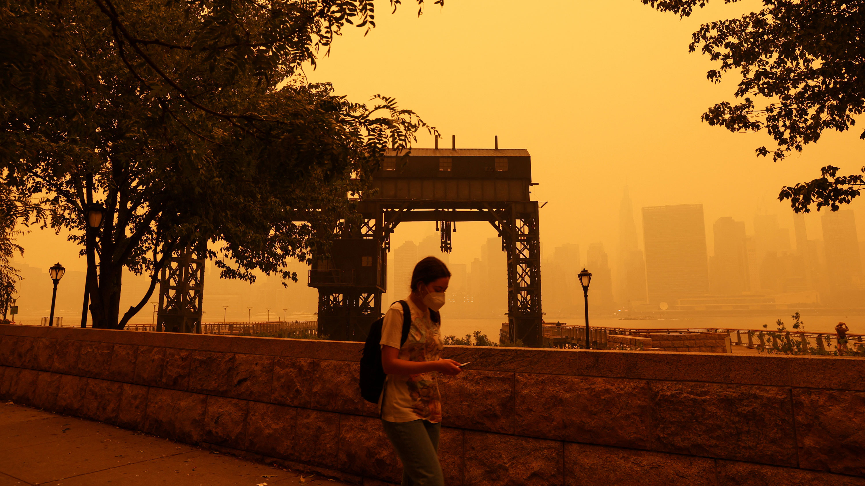
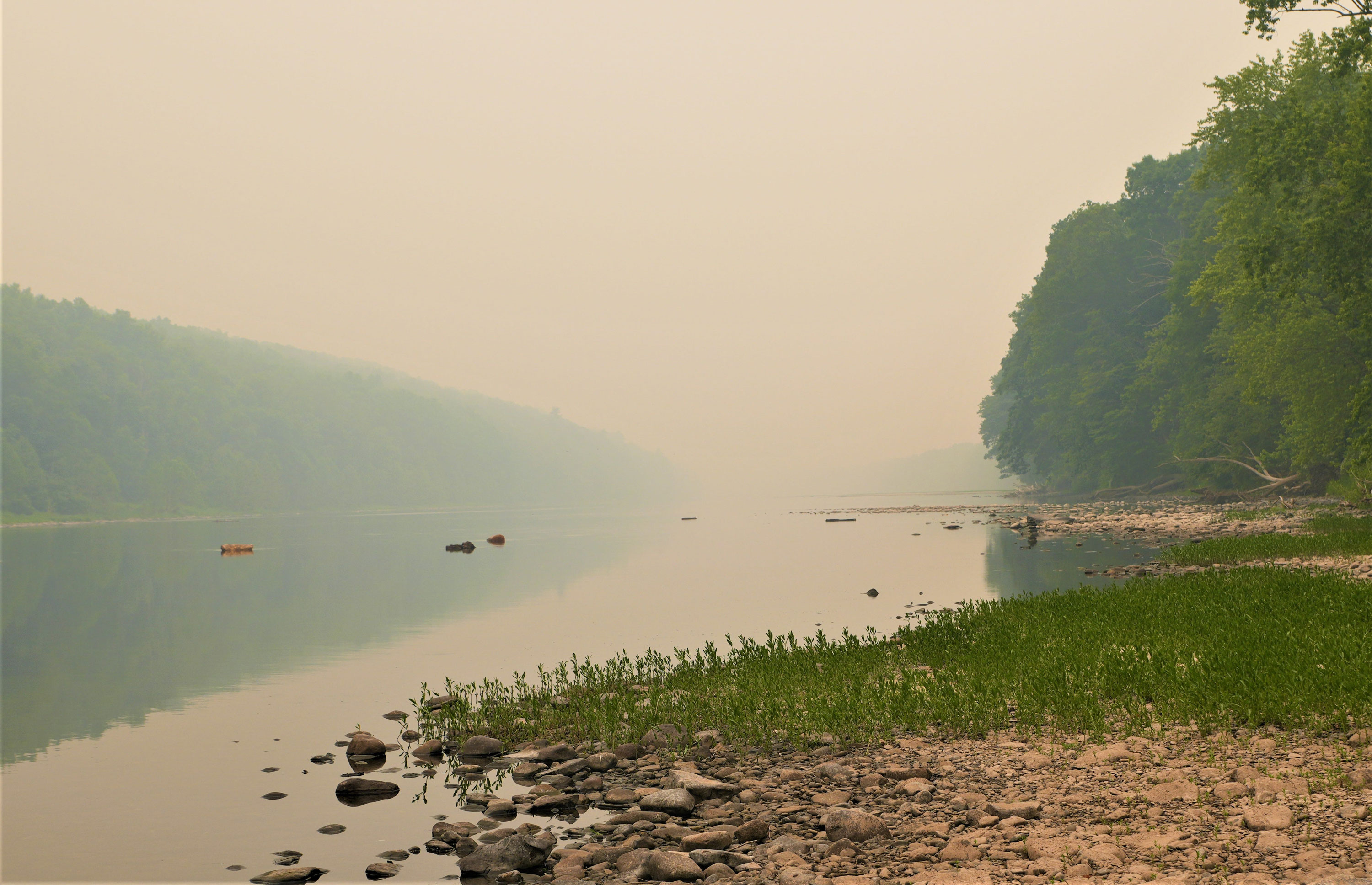
Several hundred wildfires are continuing to burn across several Canadian provinces, with an ongoing impact on impact air quality for vast swaths of the North American continent.
The air quality in Toronto was assessed to be among the worst in the world.

As the U.S. prepares to celebrate the July Fourth holiday, its northern neighbors are marking Canada Day on Saturday, but the kinds of group celebration that normally entails are difficult — or unsafe — in several parts of that country. In Montreal, the poor air quality has prompted officials to cancel many outdoor activities, and they have begun handing out N95 face masks to residents, as recommended whenever the air quality index breaches 150.

That smoke is again heading south to parts of the Midwest and East Coast of the United States. It's the worst Canadian wildfire season on record thanks to unusually high temperatures and dry conditions. The fires are raging from as far west as British Columbia to the eastern province of Nova Scotia. They are also found in heavily populated Quebec, though recent rainfall means more than 2,000 residents who have been evacuated from their homes can now start to return.

NASA satellites have recorded some of the smoke trails traversing the Atlantic too, as far afield as Spain and Portugal.

And there is little end in sight, so early in the season, which typically begins in May but continues through October. The worst blazes normally occur in July and August as temperatures spike, but emergency officials across several provinces are girding for an unprecedentedly widespread intensification.

Over the past several weeks since the first fires began in Alberta, roughly 20 million acres have been burned.
June 26
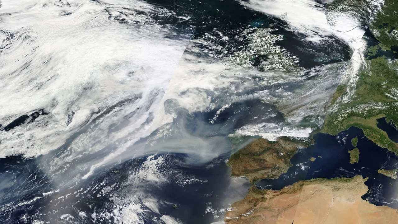
Canada has officially marked its worst wildfire season on record, with smoke from Canada's record-breaking fire season having crossed the northern Atlantic and now impacting portions of Western Europe, according to the UK Met Office.

Canada has had a dramatic start to wildfire season, with at least 18,688,691 acres already charred across the country. Wildfire activity in Canada typically peaks from June to August, leaving more than half of the peak season still to come.

As a result of the unprecedented start to the wildfire season, this year has become the worst fire season on record, surpassing the previous benchmark set in 1995 for the total area burned.
June 16
Montrealers woke up to more hazy skies on Friday, with wildfire smoke prompting another smog warning from Environment Canada.

The agency is cautioning people with heart disease, asthma and other respiratory ailments to avoid strenuous physical activity outdoors.

There were over 100 active forest fires in Quebec as of Friday morning. It's the province's worst wildfire season in recent memory, with over 160 blazes burning at the peak of the crisis earlier this month.

According to Quebec's forest fire fighting agency, SOPFEU, over 900,000 hectares have burned so far, while the seasonal average is around 2,000 hectares.
June 15
Thanks to recent rain and favorable winds, roughly 2,000 residents from Tumbler Ridge, B.C., were allowed to return home.

An evacuation order was also lifted for the town of Edson, Alta., and the surrounding area, allowing more than 8,000 to return.

The ending of the order in Alberta comes six days after flames jumped fireguards outside the town 200 kilometers west of Edmonton and forced residents to get out.

Federal Emergency Preparedness Minister Bill Blair says: “The hot, dry and windy conditions in parts of Western Canada and Ontario are exacerbating an already dangerous set of circumstances, and we know the peak of the wildfire season may still be several weeks away.”

As of the afternoon, the Canadian Interagency Forest Fire Centre was reporting 446 active fires, of which 217 are out of control. The center was reporting 127 fires in Quebec, 83 in Alberta, 70 in British Columbia and 56 in Ontario.
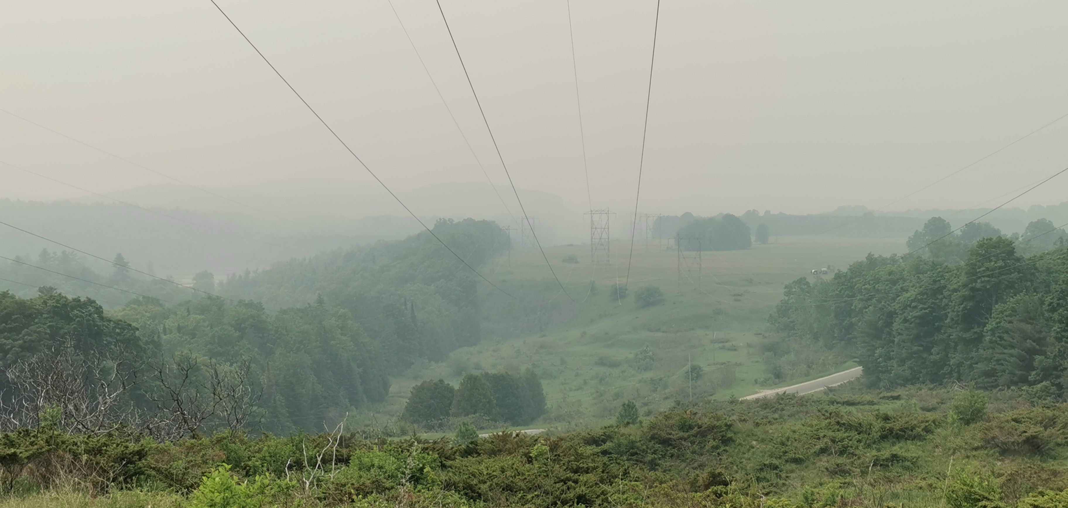
June 07
The smoke from wildfires has led to hazy sky conditions, here as seen near Ottawa.

The smoke from wildfires has also led to the sun appearing red in some places, here as seen near Owego, New York.

Smoke from the fires caused air quality in Ottawa on June 5–7 to hit the highest level on Environment Canada's Air Quality Health Index, the worst in Ontario. Air quality also hit the highest level in Kingston and Belleville, Ontario. An air quality statement was also issued for Toronto, as well as most of Southern Ontario.

The Weather Network predicted that all of eastern Ontario and parts of southern Quebec would experience even higher concentrations of low-level smoke on June 7, resulting in the worst air quality in a lifetime for much of the region.
June 06
The smoke from the wildfires drifted into the Northeastern United States and triggered air quality alerts for most of New York and some of the surrounding states. It covered many areas like New York City in haze early.
June 05
A combined total of 211 wildfires are reported by the Ontario and Quebec governments; 145 of them are considered to be out of control. Currently, 400 firefighters are working in Quebec. Air quality is expected to be impacted for both provinces and several neighboring states in the U.S. Due to an unseasonable stretch of hot and dry conditions, fire risk is at dangerous to extreme levels in both provinces.

Four communities west of Calabogie, Ontario were under evacuation orders beginning due to a fire in Greater Madawaska.
June 02
The 2023 Central Canada wildfires are a series of ongoing wildfires in the Central Canadian provinces of Ontario and Quebec.
Around 10,000 residents in Quebec were forced to evacuate their homes.
Quebec's Public Security Minister François Bonnardel said that he had reached out to the federal government to seek the assistance of the Canadian Armed Forces.
2016
May 01
The "Fort McMurray wildfire" in Alberta gained significant attention. This fire started and quickly grew in size, forcing the entire population of the city of Fort McMurray, approximately 88,000 people, to evacuate. The fire eventually spread to cover an area of about 590,000 hectares (1.5 million acres). It destroyed thousands of structures and became one of the costliest disasters in Canadian history.
2011
May 14
A notable forest fire in Canadian history is the "Slave Lake Fire" that occurred in Alberta. This fire started near the town of Slave Lake and quickly spread due to strong winds and dry conditions. The fire destroyed approximately one-third of the town, including numerous homes, businesses, and infrastructure. It burned an estimated 590 square kilometers (230 square miles) of land.
1995
At least 17,559,303 acres were burned in the country, according to fire statistics from the Canadian Interagency Forest Fire Centre.

Since 1990, “wildland fires” across Canada have consumed an average of 2.5 million hectares a year.
1919
July 29
One of the largest forest fires in Canada's history is known as the "Great Fire" or the "Matheson Fire." It occurred in the province of Ontario and is estimated to have burned an area of approximately 2.5 million hectares (6.2 million acres). This massive fire started on July 29 and burned for several weeks before it was finally brought under control. The fire destroyed several communities and caused significant loss of life and property.