- hot-spots
- nuclear issues
- Marshall Islands
- The Nuclear Tomb, the Marshall Islands
The Nuclear Tomb, the Marshall Islands
Marshall Islands
last update:
8 months agoProblems
The Marshall Islands officially the Republic of the Marshall Islands is an island country near Kiribati in the Pacific Ocean, slightly west of the International Date Line. Geographically, the country is part of the larger island group of Micronesia
Nuclear tests by the United States military
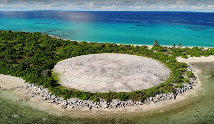
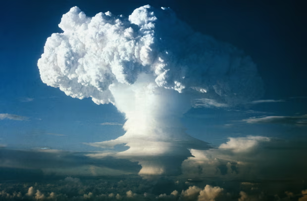
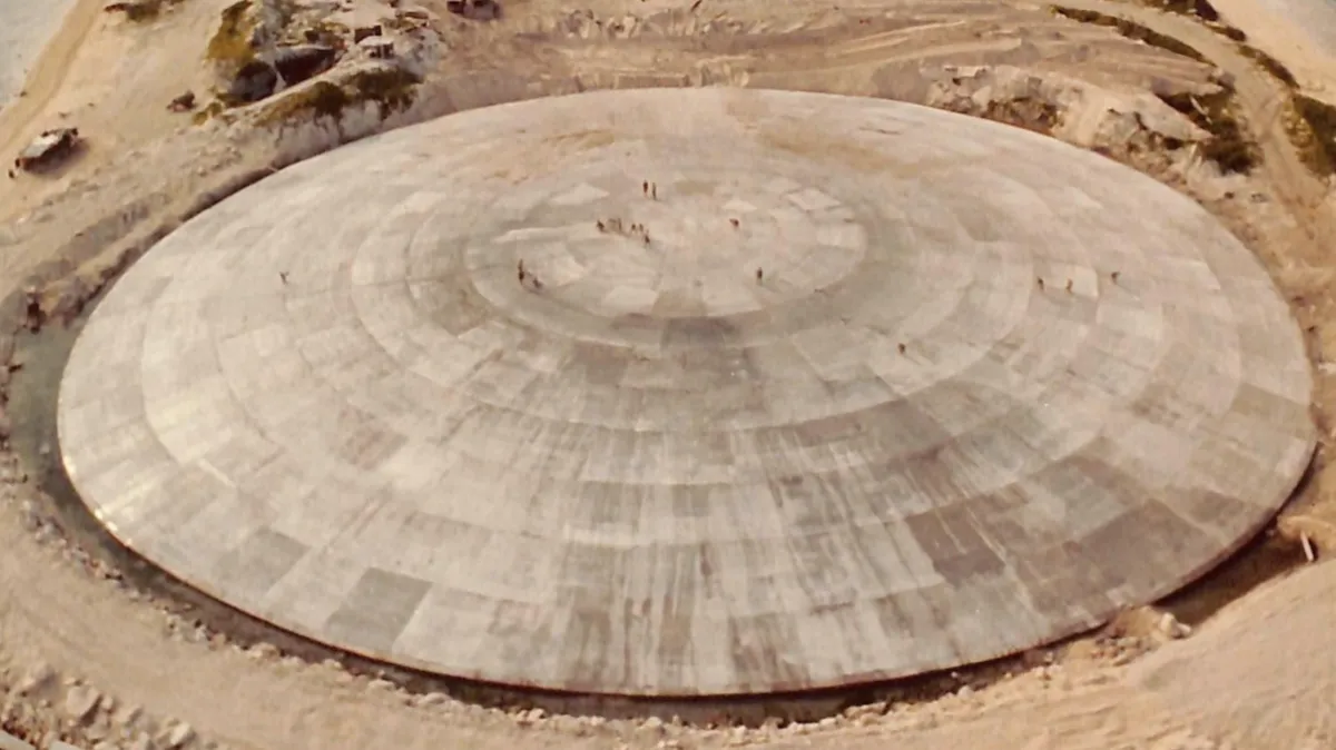
Between 1946 and 1958, the U.S. conducted 67 atmospheric nuclear weapons tests in the Marshall Islands, 43 of which were conducted at Enewetak Atoll. Radioactive fallout from these tests resulted in environmental contamination.

From 1977 to 1980, around 4,000 US servicemen were tasked with cleaning up the former nuclear testing site of Enewetak Atoll. The waste soil and other radiologically contaminated debris were mixed with cement grout, placed inside the crater formed from the Cactus nuclear weapons test, and covered with a circular, dome-shaped concrete cap to help protect the waste pile below from natural erosion. It all went into the Runit Dome (or Cactus Dome), which the service members then covered with concrete.

Sea levels in the Marshall Islands are increasing, and by 2030, they may rise by 1.2 to 6.3 inches, leading to increased storm surges and coastal flooding. If the trend continues, the dome could be underwater by 2100.

The dome recently began to crack and chip, increasing the odds that strong waves could force the structure open. A disaster like that would send even more radioactive waste into the nearby ocean or lagoon, which could even force locals to leave the island once again.

The site has remained a concern to the people of Enewetak and their leadership. After the construction of the Runit Dome, the United States was required to monitor the containment structure under the United Nations’ Trusteeship of the Marshall Islands.
Gallery
4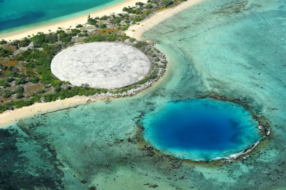
Timelines
2023
The United States and the Republic of the Marshall Islands signed a memorandum of understanding (MOU) on a new Compact of Free Association agreement that will govern relations between the two nations for 20 years.
2019
The Science Director of the LLNL Marshall Islands Dose Assessment & Radioecology Program offered a presentation at the 2019 DOE/RMI Annual Meeting in Majuro on the DOE monitoring activities at the Runit Dome under the Insular Areas Act of 2011. This meeting was attended by DOE officials, including the Associate Under Secretary for Environment, Health, Safety, and Security, the U.S. Ambassador to the Marshall Islands and other officials from the U.S. Embassy, officials from the U.S. Army Garrison Kwajalein Atoll, and Representatives from the RMI national and local government.
2018
The U.S. Ambassador accompanied a delegation from DOE, led by the Science Director of the LLNL Marshall Islands Dose Assessment & Radioecology Program, on a tour of the Cactus Crater containment structure to review field operations conducted in support of the Insular Areas Act of 2011. RMI officials were also invited.
2017
The Science Director of the LLNL Marshall Islands Dose Assessment & Radioecology Program provided an informal briefing for the RMI Minister-in-Assistance and the Senator from Enewetak on the Runit Dome.
2016
The U.S. Ambassador accompanied DOE officials, including the Associate Under Secretary for Environment, Health, Safety and Security and the Director of the Office of Health and Safety, as well as the Science Director of the LLNL Marshall Islands Dose Assessment & Radioecology Program on a visit to Enewetak Island to meet with the local community and tour the whole body counting facility. The delegation also viewed the Runit Dome and Runit Island. The Mayor of Enewetak traveled with the group, and RMI national government officials were also invited.
2015
The U.S. Ambassador to the Marshall Islands accompanied a delegation from DOE and the RMI, led by the Science Director of the LLNL Marshall Islands Dose Assessment & Radioecology Program, to inspect the condition of the Cactus Crater containment structure in the aftermath of Tropical Storm Nangka.
2012
Congress passed P.L. 112-149, Insular Areas Act of 2011, which amended the Compact of Free Association Amendments Act of 2003 by assigning Cactus Crater containment monitoring and reporting requirements to the Secretary of Energy (Secretary). Effective January 1, 2012, the Secretary was required to “periodically (but not less frequently than every 4 years) conduct -- (I) a visual study of the concrete exterior of the Cactus Crater containment structure on Runit Island; and (II) a radiochemical analysis of the groundwater surrounding and in the Cactus Crater containment structure on Runit Island.”
1986
Congress passed P.L. 99–239, Compact of Free Association Act of 1985, which, among other things, required the U.S. and the Government of the Marshall Islands to enter a separate agreement that would come into effect simultaneously with the Compact. In that agreement, among other things, the U.S. agreed to provide dosimetry and bioassay services and related assistance to the people of the Marshall Islands. The Government of the Marshall Islands assumed responsibility for and controlled the utilization of areas in the Marshall Islands affected by the nuclear testing program, thereby ending the U.S. role and responsibility for the Runit Dome.
1979
Construction of the containment structure "The Runit Dome" was completed.
1975
The U.S. conducted cleanup operations at the Enewetak Atoll by stripping off successive layers of contaminated soil to reduce the level of Pu in surface soils. The waste soil and other radiologically contaminated debris were mixed with cement grout, placed inside the crater formed from the Cactus nuclear weapons test, and covered with a circular, dome-shaped concrete cap to help protect the waste pile below from natural erosion.
1948
The U.S. conducted 67 atmospheric nuclear weapons tests in the Marshall Islands, 43 of which were conducted at Enewetak Atoll. Radioactive fallout from these tests resulted in environmental contamination.
1947
In 1947, before the start of nuclear weapons testing on Enewetak, the approximately 150 residents of Enewetak Atoll were relocated to Ujelang Atoll, approximately 155 miles southwest of Enewetak.