Problems
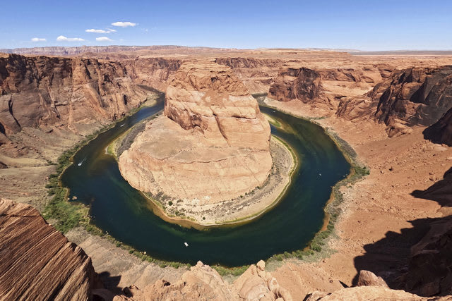
The Colorado River is approximately 1,400 miles long and originates along the Continental Divide in Rocky Mountain National Park, Colorado, and ends where it meets the Gulf of California in Mexico. The Colorado River is a critical resource in the West because seven basin states (Arizona, California, Colorado, Nevada, New Mexico, Utah, and Wyoming) depend on it for water supply, hydropower production, recreation, fish and wildlife habitat, and other benefits.
Causes of water level decrease in the river
Most of the water in Colorado comes from the snow that falls in the Rockies and is slowly released, a natural reservoir that disperses its bounty gradually over months. But since 2000, the Colorado River Basin has been locked in what experts say is a long-term drought exacerbated by climate change, the most severe drought in the last 1,250 years, tree ring data show.

The river has been entirely used up for decades, leaving dusty stretches of desert where it once flowed to the sea in Mexico. Now, chronic overuse and the effects of climate change are pushing the river system toward potential collapse as reservoirs drop to dangerously low levels. A water reckoning is about to transform the landscape of the Southwest.
Consequences of the river drying up
The future of farms and ranches that depend on Colorado River water is still being determined. Agriculture uses about 80 percent of Colorado’s flow to irrigate 6 million acres of crops, the largest share of which is alfalfa grown to feed cattle; cities use just 10 percent.

Invasive plants, such as salt cedar and cattails, now dominate the delta, a landscape of seemingly endless mud flats where forests used to stand. And in the Gulf of California, shellfish, shrimp, and waterfowl have declined dramatically as fresh water has dried up.

However, the biggest cloud looming over the Colorado River Basin is whether the region is entering a completely new era, a permanent change as opposed to a temporary one, caused by a planet being rapidly warmed by human activity.
Gallery
5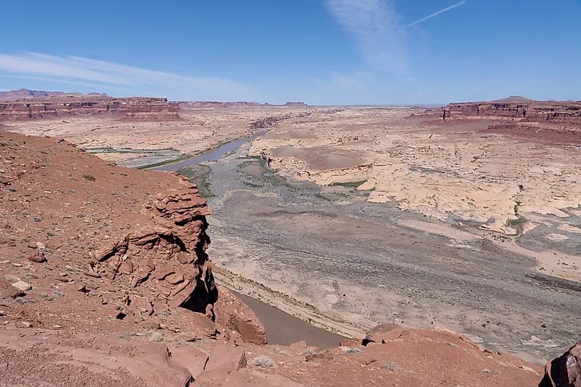


Timelines
2026
July 28
The Colorado River has been shrinking. Over the last 27 years, its flows have dropped by 20% compared with the 20th century average, said Brad Udall, senior water and climate research scientist at Colorado State University’s Colorado Water Center.

Since 2020, the river’s flow has been about 10.2 million acre-feet on average per year — that’s a 33% decline, he said.
“That’s a stunning drop. There’s nothing like it in the historical record,” dating back to 1906, Udall said.

Some people also argue that climate change is the cause, not water use.
July 27
A Colorado official says the plan calls for Lower Basin states to cut 3.2 million acre-feet of water use over two years. Plan calls for nearly doubling cuts from 2029 to 2036. Lower Basin states say Upper Basin also should face cuts. A U.S. plan for sharing the waters of the drought-stricken Colorado River would require Arizona, California and Nevada to cut their water use by a fifth in the next two years and to make even deeper reductions later, a senior water official from one of those states said. The official said the plan should include reductions for Colorado, New Mexico, Utah and Wyoming, the four other states deadlocked over the future of a river. The U.S. Bureau of Reclamation is expected this week to adopt a short-term proposal by Arizona, California and Nevada, known as the Lower Basin states, to cut their water use by 1.6 million acre feet in 2027 and 2028, for a total of 3.2 million acre feet, equivalent to cutting their current allotment by 21%, the state official said. The cuts for Lower Basin states could nearly double in 2029 through 2036 to up to 3 million acre feet in each of those years to maintain critical reservoir water levels, the official said. The 10-year plan would be up for review every two years, based on water conditions.
July 23
The states have been negotiating for three years on how to replace the current 20-year plan that expires at the end of 2026. The Upper Basin states have rejected making cuts. They say they already face reduced supplies from decades of drought and that deeper cuts by Lower Basin states — which use most of the river's water — are needed to stabilize the Colorado. The Lower Basin states of Arizona, California and Nevada have put forth a plan with some mandatory cutbacks to rein in demand on the shrinking Colorado River. The Upper Basin states of Colorado, Utah, Wyoming and New Mexico have not agreed to mandatory cutbacks. A previous meeting of the seven governors, held early this year, also failed to yield a seven-state consensus, causing the states to blow through a federal deadline with no deal and no apparent consequences.
2023
Colorado River officials have been working since 2023 on a new set of rules for how to release and store water in two immense reservoirs, Lake Powell on the Utah-Arizona border and Lake Mead on the Arizona-Nevada border.

The 2023 Plan builds on the initial 2014 plan and further enhances community involvement with four focus areas—Vibrant Communities, Robust Agriculture, Thriving Watersheds, and Resilient Planning—through the development of new water projects and the improvement of existing infrastructure to support agricultural, urban, and environmental needs.

Specifically, it outlines strategies to address the state’s water supply challenges, including population growth, drought, and climate change. It also lays out the state’s goals for water conservation, water storage, water quality, and stakeholder engagement.
2022
With the water levels in Lake Mead and Lake Powell continuing to drop, federal officials announce deeper water supply cuts for Arizona, Nevada, and the country of Mexico in 2023 and further direct the seven states and tribes that rely on the Colorado River to develop plans to reduce consumption by 2 million to 4 million acre-feet a year.
2019
President Trump signs the Drought Contingency Plan. The DCP commits the seven Colorado River Basin states — California, Nevada, Arizona, Colorado, New Mexico, Utah, and Wyoming — to a plan centered on the idea that all water users, not just those with junior water rights, have a stake in keeping the system whole by taking voluntary reductions on their Colorado River deliveries.
2018
Bureau of Reclamation releases Tribal Water Study. It describes how tribal water use fits into the overall picture of Colorado River management, how future development of tribal water resources will alter river operations (including others using water to which a tribe may hold legal title), and how future development of tribal water rights will affect Basin operations.
2017
The United States and Mexican governments signed an agreement to the 1944 Water Treaty between the two countries called Minute 323. The Minute extends 2012’s Minute 319, giving Mexico greater flexibility in managing its Colorado River allotment. The latest agreement provides mechanisms for increased conservation and water storage in Lake Mead to help offset the effects of drought and prevent a shortage from being triggered. Minute 323 dedicates 210,000 acre-feet of water over nine years for environmental restoration work in the Colorado River Delta.
2016
Major water suppliers in the Lower Basin begin work on a Drought Contingency Proposal that would ensure Arizona, California, and Nevada are enrolled in what they agree is a shortage-sharing platform to avoid the undesirable aspects of Lake Mead falling to 1,025 feet above sea level – the lowest shortage trigger level contemplated in the 2007 Guidelines.
2014
A pulse flow is released into the Colorado River Limitrophe (the 24-mile stretch that forms the U.S.-Mexico border) and Delta. Water flows to areas being restored by conservation groups and sets the stage for future management of what were once more than 2 million acres of riparian habitat and wetlands vital to birds and wildlife.
2012
U.S.-Mexico Minute 319 was signed, creating a binational framework to address shortages and allowing Mexico to store unused water in Lake Mead.
2010
Mexico and U.S. subsequently signed Minute 318, an interim agreement that allows Mexico to store part of its allocation in Lake Mead. At the same time, repairs were made to infrastructure damaged during the April 2010 earthquake.
2008
Third experimental high-flow release from Glen Canyon Dam to study effects on beaches and endangered species.
2007
Seven States Agreement and federal ROD signed; includes Lower Basin shortage guidelines and rules to store conserved water in Lake Mead and agreement to “equalize” storage in Mead and Powell.
2003
Quantification Settlement Agreement signed, enabling water transfer between IID and SDCWA and gradual reduction of California use to 4.4 million acre-feet.
2000
States negotiate Interim Surplus Guidelines.

Environmental groups sue over Mexican Delta.

Multiyear drought begins on the Colorado River.